Entry Points:

About White Pine County
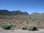
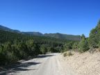
Miles of alternating mountains and valleys make up the 8,876 square miles of White Pine County. Mountain peaks can reach above 12,000 feet, and are often snow-capped with beautiful forests gracing their slopes. Valley floors range from about 5,500 feet to above 6,000, and are barren except for sagebrush, creosote, tufts of grass and other desert plants which can survive the hot, dry climate and alkaline soil. Creeks flowing out of the mountains disappear into the dry soil in the valley. The valley floors are usually flat, having been filled in by sediment under ancient lakes. At the feet of the mountains, the ground suddenly begins a gentle, steady slope upward until it meets the steeper sides of the mountain.
With a population of 9,181 inhabitants as of the year 2000, (and half of them in Ely), White Pine County is virtually uninhabited. Mining supports most of the population, and little farming is possible, due to lack of water, although cattle are grazed on the mountain slopes.
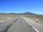
Most people traveling through the county see only the desolate valleys. Despite the grandeur of their size, and the serenity of their isolation, it is hard to make a case for them as tourist attractions. For the most part, the majestic mountains are less frequented than the highways, with the exception of Great Basin National Park, which is a misnomer since the Snake Mountain Range covers entire park, and none of the surrounding basins are included.
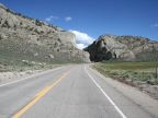
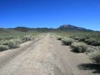
Three U.S. highways serve White Pine County. U.S. Highways 6 and 50 traverse it from east to west. They share the same route on their entry from Utah on the east, and divide near Ely, with Highway 50 heading northwest, and Highway 6 heading southwest. U.S. Highway 93 crosses the county from north to south. Hundreds of other roads and a few state highways cover the remote parts of the county.
With the large area covered by White Pine County (more than the state of Massachusetts), the number of mountain ranges and valleys across it is remarkable. They generally run in parallel lines from north to south, although there are gaps and branches.
Mountains:
Snake Range, Schell Creek Range, Egan Range, White Pine Range, Antelope Range, Cherry Creek Range, Butte Mountains, Pancake Range, Diamond Mountains
Valleys:
Steptoe Valley, Spring Valley, Butte Valley, Long Valley, Newark Valley, Jakes Valley
For More Information:
See Wikipedia's White Pine County page.