Entry Points:

About Ely
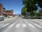
Ely occupies a spot at the mouth of Robinson and Murry Canyons where they emerge from the Egan Mountain Range into Steptoe Valley. Ward Mountain, a part of the Egan Range, is the focal point to the scenery south of Ely, a ridge running several miles at elevations above 10,000 feet. Murry Canyon heads southward from downtown Ely into the foothills for Ward Mountain. Robinson Canyon heads eastward, and the historic downtown lies at the point where they meet, while the town has expanded eastward into the valley.
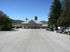
Ely was established as a stagecoach station long the route of the Pony Express in the late 1800s. In 1906 copper was discovered in the Egan Mountains, and Ely experienced a mining boom. The Hotel Nevada is one of many buildings built during this period, a six-story structure which was the tallest building in Nevada until 1940. It still operates today. The Mormon Church built the Ely Tabernacle in 1926, which serves today as a community fine arts center. Many other old buildings of the period characterize the downtown area.
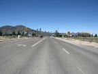
Ely benefits from being a junction of the major highways of central Nevada. U.S. Highways 6 and 50 meet at Ely. Highway 6 approaches from the southwest through Murry Canyon, and Highway 50 descends through Robinson Canyon from the northeast. They both meet U.S. Highway 93 on the east side of town. Highway 93 travels north through Steptoe Valley to McGill, a town a few miles to the north where the smelter and mill for the mines was located. All three routes are combined leaving Ely to the southeast. They cross the Schell Creek Range and divide at Major's Place on the other side.
Ely is close to Great Basin National Park, some twenty miles east on highways 6 & 50. Cave Lake State Park is in the mountains on the east side of the valley, and the Ward Charcoal Ovens State Historic Park is to the south.
Ely is the county seat of White Pine County, and also its largest city. The population was 4,255 at the 2010 census. The elevation is 6,300 at the eastern edge of town, and houses reach up to about 6,600 feet on the south side of town. The higher elevations bring a little moisture to the dry Nevada climate, and also milder summers.
For More Information:
The White Pine Tourism and Recreation Board operates elynevada.net and the Wikipedia article on Ely is informative.